 Sailing Painkiller
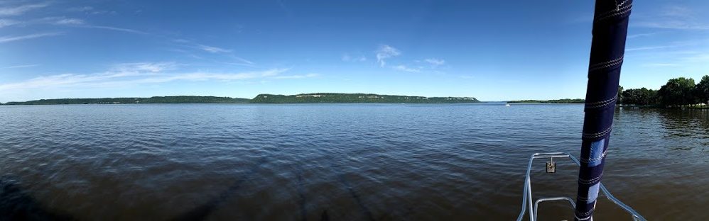

We spent a nice 3 day weekend at North Star Sailing Club. Thank you to Mike and Mike & Cheryl for the recommendation to stay here and being our hosts. We are staying in Mike’s slip while he is out and about exploring. The harbormaster at North Star Sailing Club was welcoming and accommodating! Other members welcomed us as well and stopped by to chat.
Our first full day at North Star, we were starting to think about our transit through the Welland canal and the Erie canal. We thought we would really benefit from having a couple of large round ball fenders for the boat.
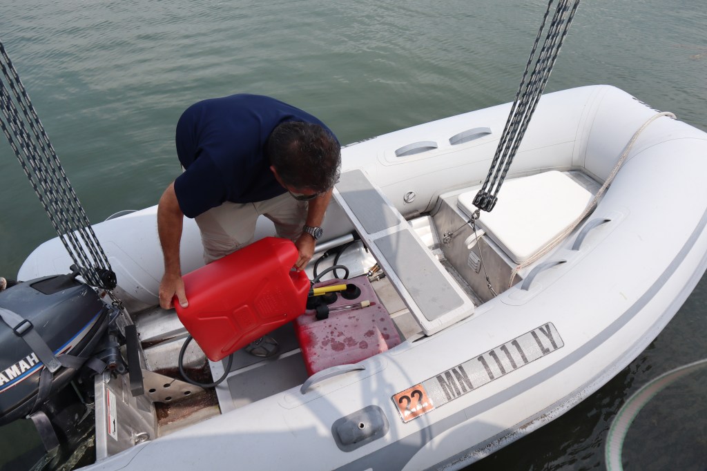
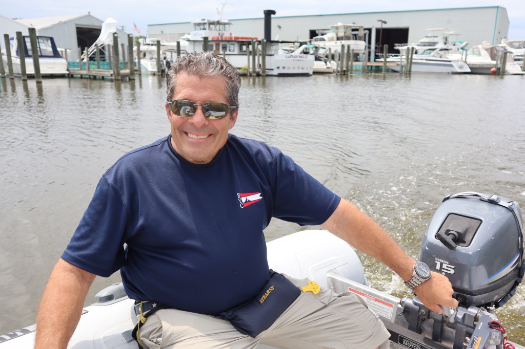
Now anytime we are in a port/harbor, we are limited to the distance we can either walk, bike (if there are bikes available), dinghy or perhaps uber (if there is such service in the area). In order to go shopping for 2 large ball fenders, we googled and found a West Marine store just a few miles from our location. The West Marine was very close to the Clinton river, where we are, just up stream a couple miles. So, we decided to hop in the dinghy and take a dinghy ride up stream to find the West Marine.
Time to gas up the dinghy!
The Clinton River and St Clair Shores which is just to our north, is referred to as the Nautical mile and boasts boating with a capital “B”. This area has one of the highest concentration of boats and boaters in the world. This also means they have a vast array of boating services available as well, so it makes sense we were able to locate a West Marine store nearby.
The Clinton River shoreline is fully lined with docks that lie perpendicular to the river and cover the entire shoreline on both sides.

We enjoyed our dinghy ride up the river!

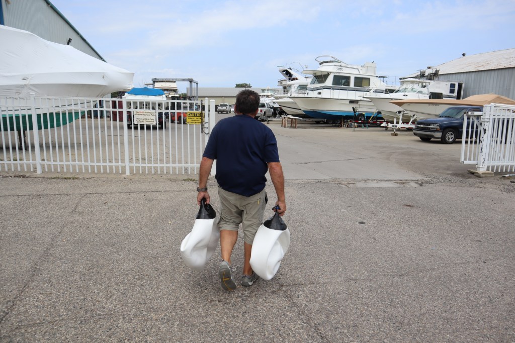
We were successful in our shopping trip and we were able to get the fenders we needed. Yes, we still have to inflate them!
We took the dinghy across the river from where the boat is to the restaurants located there to grab a bite to eat.

We also got a phone call from Mark’s brother about his mom. His mom is in the hospital after collapsing at her apartment. We are waiting for more details about really happened and for them to complete some tests to learn more.
The next day we spent quite a bit of time on the phone with family. We learned that Mark’s mom had a stroke. Lots to think about. Do we leave the boat and fly home? Where would we leave the boat? Where could we fly home from. We know that we cannot accomplish any of these things in the Clinton River. We can’t leave our boat here for an extended period of time since we are in someone else’s slip. And no real airport nearby to fly out of and no ground transportation to get us to an airport.
We spent the rest of the day pampering ourselves and had a spa day. I cut Mark’s hair and he gave me a pedicure.

We decided we should leave the next morning and head toward Detroit and Cleveland in case we do need to fly home at some point.
Later this evening we had storms roll in. We were expecting some rain, but what we didn’t expect was a tornado warning. We had been looking at the radar and the sky as the storm approached and weren’t too worried until the tornado sirens went off. Now looking at the radar is one thing, but that doesn’t necessarily tell you if there is a tornado and where it is. So, we turned on our handheld VHF radio and tuned into a radio weather station. They were talking about tornado warnings, possible tornados and radar indicated tornados and then they started listing off all the counties in the path of the storm. What county are we even in? We didn’t know! We had to do some googling to see what county we were in and listen some more to determine how at risk we were. Should we stay on the boat? Should we go into the yacht club building? Ultimately, we learned that the brunt of the storm is just to our south, so we think we are going to be just fine. We had dark and green looking sky, rain and just a bit of wind.

Once this storm blows through we should have nice weather tomorrow for our trip down the Detroit River and to Put-in-Bay, OH.
We left Lexington about 6 am. We have about 57 miles to go today. Our destination is North Star Sailing Club which is located up the Clinton River on Lake St Clair.
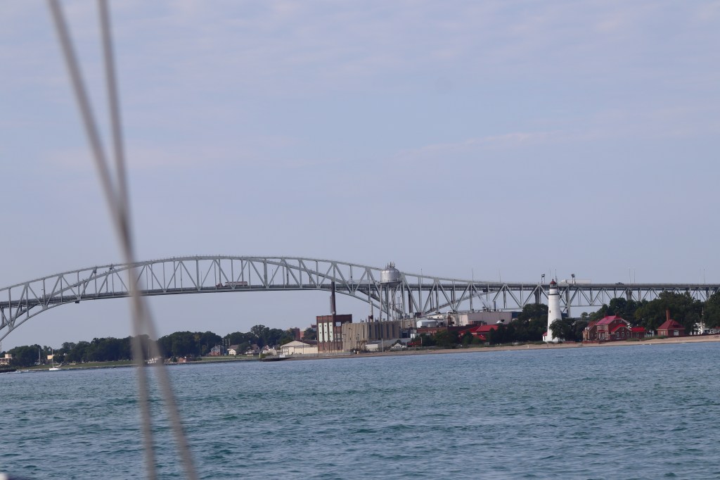
Today we will have a variety of geography. A couple of hours on southern Lake Huron before we enter the mouth of the St Clair River. The picture above is the Blue Water Bridge that marks the entrance to the St Clair River. The St Clair River is about 40 miles long and only 1/2 mile wide. Keep in mind that commercial freighter traffic and tankers come through this river as well and we need to share the 1/2 miles wide space with up to 1,000 foot freighters! The St Clair River also drops in elevation by 5 feet from Lake Huron to Lake St Clair. It is because of this drop in elevation there is up to a 2 knot current in the river.
Once we get through the river then we enter Lake St Clair. The St Clair River branches into several channels creating a broad delta region known as St Clair Flats. Words like broad delta and flats translate into shallow water. We really have to watch our depth in here.
So, today brings a variety of challenges that we haven’t yet encountered. Rivers, currents, shallow water, tight quarters with big ships. Should be an interesting day.
Once we left Lexington, we have large rolling seas for a couple of hours while we headed toward the river. Lake Huron was still churned up from the recent storms.
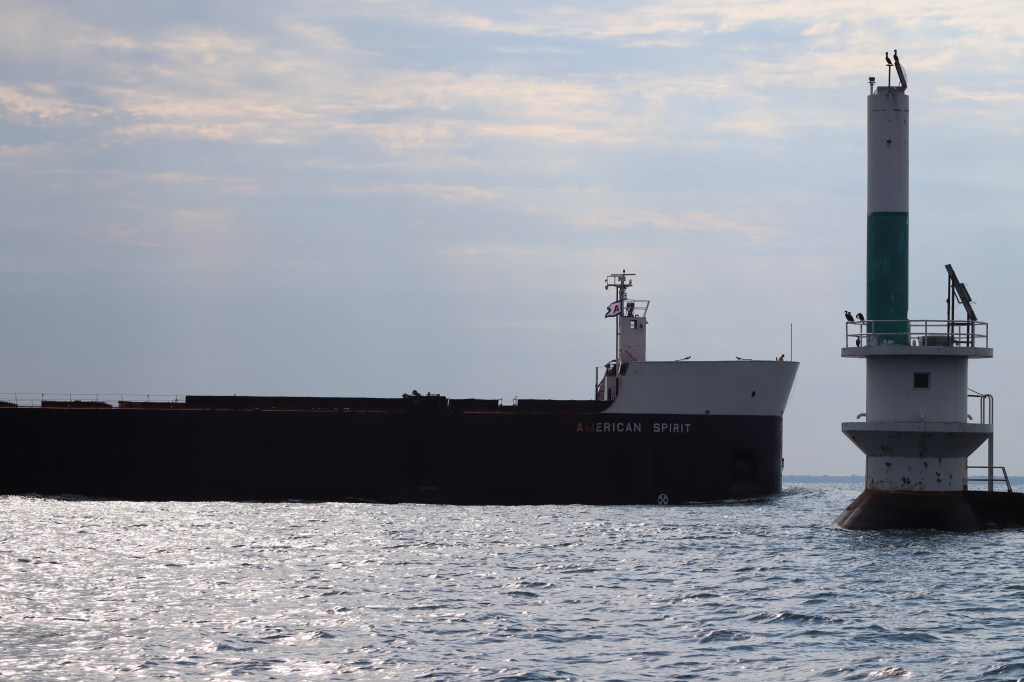
As we approached the Blue Water Bridge, there was a bunch of freighter traffic coming our way and we were trying to time to see which would be in front of us and who might be at the bridge the same time we were. We don’t want to enter the river and go under the bridge at the same time as a freighter. Never play chicken with a freighter!
A couple freighters pass in front of us. One in particular, American Spirit, it seems we are destined to encounter him at the bridge. So, we decided to make some decisive moves to turned around to head away from the bridge to let him know that he is free to go ahead and we will fall in behind him.
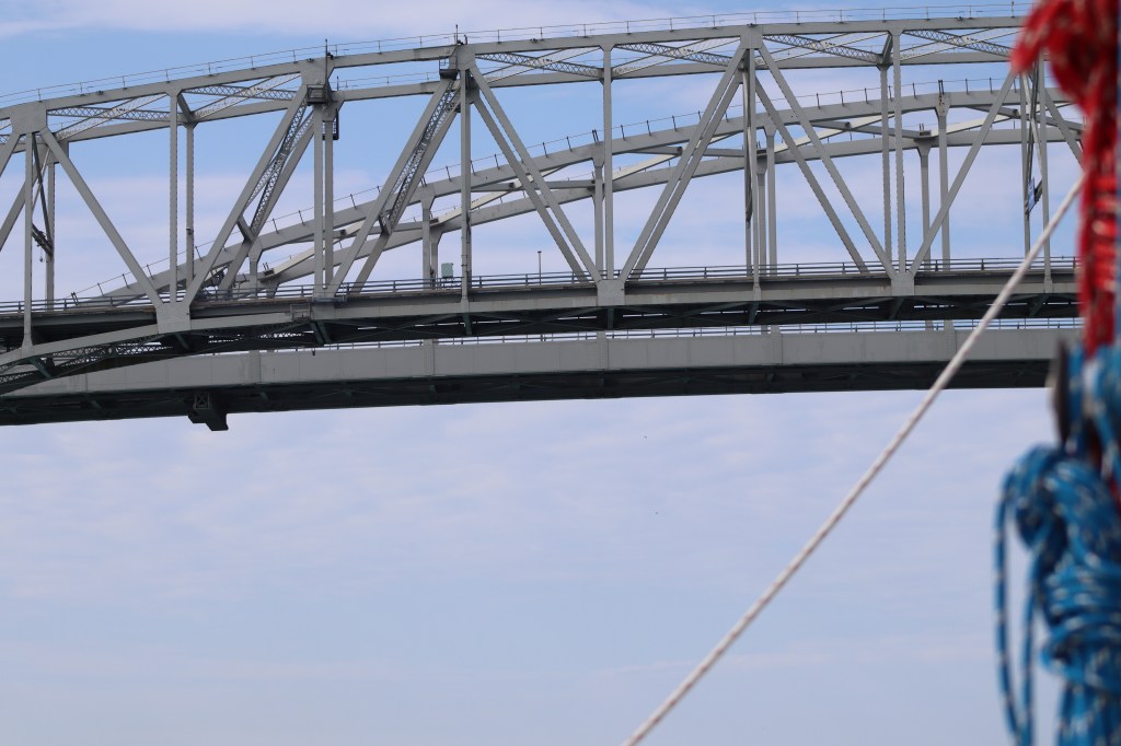
Passing under the Blue Water Bridge. It doesn’t matter how tall a bridge is, it always looks like you are going to hit it. This particular bridge has a clearance of 135 ft. We only need about 57 feet to clear, so we are good.
The St Clair River is also the dividing line between the US and Canada. The US is on the right hand side of the boat and Canada is on our left.

As we were passing under the bridge, the current became evident and pushed our boat around slightly. It increased our boat speed about 1.5 knots. The roughest area was right near the bridge and as we made our way further down the river it was just a gentle current we were riding down river.
We encountered several sailboats motoring up the St Clair River toward the Port Huron Yacht Club. They were all racing boats that are likely headed from Detroit up the river to participate in the Port Huron to Mackinac race that starts tomorrow. Port Huron Yacht Club looks all ready for the race festivities.

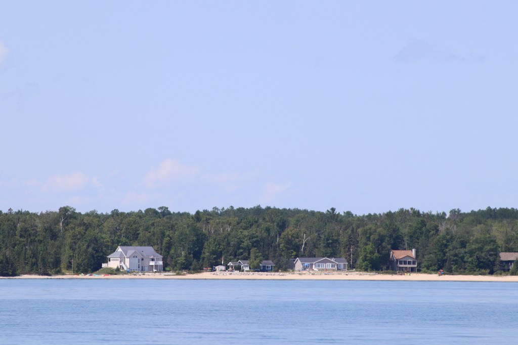
The rest of our journey on the St Clair River was quite pleasant and departure from our open water lake sailing. It was nice to see houses and scenery going by to keep the ride interesting and the time went by quickly. Lots of nice houses along the river.

We did encounter a couple of freighters on the narrow river. Here is one that passed by us. That is close enough!

Then we came to the bottom of the river where it divides into multiple channels in the delta region. We had to pick which channel we would use. This was decided for us based on our final destination of the Clinton River, we would head down the northern most channel depicted below. We had questioned multiple people we met before now about navigating this channel and it depths. All the advice we got was the same – stay in the channel! Lots of bouys mark the channel along the way. Red and green, go between! Here’s what the area looks like on the chart.
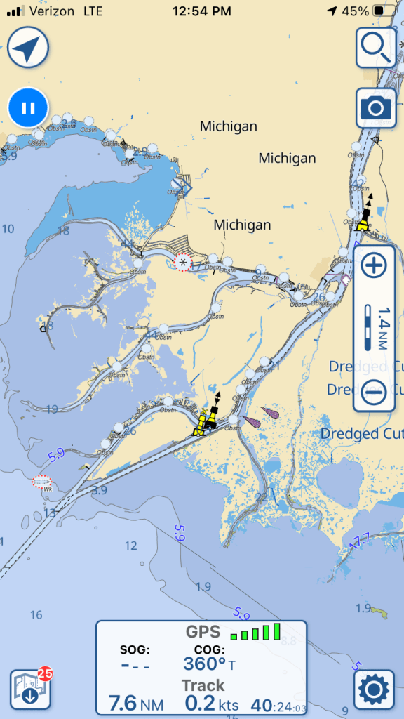
As we were heading through the northern most channel all was well until we got to the lower part of the channel that enters Lake St Clair, this is where is get the most shallow. The channel markers are now barely as wide as our boat and should we encounter another boat coming through this narrow channel, they better draft less than us, cuz we aren’t moving out of the channel. Our boat drafts 4 foot 6 inches. There were areas where we saw as little as 5 – 6 feet of water and if we moved literally a foot or two in the wrong direction we could be in 2 feet of water. It took both Mark and I to be fully attentive with both the chart plotter and ipad going to pick our way through this narrow skinny water. But success! We were now in relatively deeper water at 10 feet in Lake St Clair.
We made our way across Lake St Clair and about a mile up the Clinton River to dock at the North Star Sailing Club. We plan to be here for a couple of days!

We left Harbor Beach at about 6 am, but only have about 38 miles to go today. That should be relaxing and a piece of cake compared to our 80 mile day. We know we have some weather coming in for the next couple of days, so we want to get there as early as possible to avoid any weather that might be earlier than expected.
We were a little anxious about Lexington marina since we have heard stories from other boaters about how narrow their fairways in the marina are and with a full keel and no bow thruster we are not as nimble in tight spaces as other boats. They do have some nice accessible slips on the outside, however when I made reservations none of these slips were available and we had to select a slip on the inside in the tight fairways.
We had a beautiful sail all the way to Lexington with no motor for a change. As we made our way closer to Lexington the winds were slowly increasing all day. We were a bit concerned coming in with increasing winds and tight fairways. So, once we got into the marina we decided to stop at the fuel dock to fill up the diesel tank and pump out first. This is a good way to make a successful landing to check out the lay of the land before we have to move to a slip.
The marina staff were very welcoming and helpful. Before we even had a chance to ask, they took note of the increasing winds, took a look at our heavy boat and asked in we would like to use one of the slips on the outside. YES! Thank you! We were grateful they were so accommodating to allow us to move to slip that would be much easier to maneuver to. With the help of the marina staff we were able to land successfully in the nice wide open slip.
The winds continued to increase and we watched as multiple boats were all pulling into the marina after us for the next few hours. It was the kind of day that everyone available on the dock was at hand to help people land their boats in gusty conditions. When the weather is like this it doesn’t matter how pretty your landing, just that you land without hitting anything.
We got in early enough that we walked up the hill to town just a few blocks away and found a great little burger place for lunch. Wimpy’s Burgers, yes, just like Popeye. It had a small town diner feel to the place with a counter and open kitchen with a soda fountain. Delicious!
We made our way back to the boat and the increasing winds were indeed signaling a change in weather and was a warning to the approaching storm front that was coming our way. The storm hit with full force about 4 pm complete with 40 – 45 mph winds, small hail, heavy rain, etc. So glad we left early and were safely at the dock!
The next day the winds were still howling out of the north due to the storm front, so we are staying put for another day. So, the day was spent catching up on boat projects, writing blog posts, cleaning and relaxing.
When traveling by water, we are blessed to meet other like minded people who are also traveling places by water. If you are not familiar with what is called America’s Great Loop, let me introduce you.
America’s Great Loop is a route that boaters up the east coast, west through the great lakes, south through the Mississippi river and then east across the Gulf of Mexico. There are multiple people who take this route and typically take about a year to complete the full loop. These boats are referred to as “loopers”. Generally, one would go north on the east coast in the Spring, west through the great lakes in the summer months, south on the river in the fall and east across the Gulf of Mexico in the winter.
Although we are generally following this route, we are going in a clockwise fashion, heading east through the Great Lakes and south on the east coast. This is the opposite direction of what many loopers are heading. We will not complete the entire loop and our purpose is to get to the Bahamas!

Lexington is one of the first stops that we are starting to encounter some “loopers” who are headed in the opposite direction of us. We met Tom and Theresa, Loren and Lisa and Mike and Ginny. Conversations led to happy hour on the dock which then led to dinner at a near by restaurant called Windjammer. It was a really fun night and it was great to be able to exchange stories and information about our route ahead of us since they were coming from that direction and we were able to share with them what was ahead for them.
The next segment of our journey will be a little different than the big lake sailing that we have done so far. The next segment will involve narrow rivers, the St Clair River and Detroit River and an inland lake, Lake St Clair. We have concerns about rivers and current, where to stay and shallow water in Lake St Clair. It’s always so helpful to get first hand information about places we are going from someone who has been there recently.

Alpena, MI to Harbor Beach, MI is about 80 nautical miles. At 5 knots per hour this trip would take us about 16 hours. We hope to make the journey in less time than 16 hours, so we will have to go faster than 5 knots for sure.
Why are we going so far today? Remember I was saying that good harbors are few and far between on this side of Lake Huron. There were a couple of alternatives. We could have made a stop in Harrisville, however no reservations to be had. We could have stopped in Port Austin, however we had heard they had a recent tornado go through town and things are not up and running there. The other consideration is weather. We have really nice weather for about another day or so and then it’s supposed to turn for the worse, so we want to be tucked in some where when that happens. Also, see that big bay on the left of the map? That’s Saginaw Bay. If the winds are out of the west, the exposure to wind and waves crossing Saginaw Bay can make things uncomfortable.
So, 80 miles it is.
The alarm went off at 4 am. If we were going to do an 80 mile day, we have to get going early. We thought we would leave the dock around first light. We miscalculated the sunrise slightly however and it was still very much dark when we were ready to leave the dock.
To get into Alpena, there is a long narrow channel marked with channel bouys and very shallow water outside of the marked channel. As soon as we left the protection of the marina we quickly realized that none of these bouys are lit. We have our chart plotter that shows us the path that we took to get into Alpena, so that will help provide a bit of a bread crumb trail to help us get out in the dark. However, Rose still had to get out the spotlight and stand on the bow to shine our powerful light to help identify the bouys on the way out of the harbor.
Did I mention that Alpena is a long way in? We hunted for bouys, shined the light and slow picked our way out in the dark for about an hour until we reached the end of the long line of bouys. Note to self, let’s leave after sunrise from now on.
Of course once we reached the end of the long line of bouys, the sky was bright enough to be able to see where we were heading.
We spent the whole day just making sure the boat was moving at an appropriate speed. We managed to average about 6.5 knots most of the day with all 3 sails flying and the engine assisting us to maintain our speed.
Over the course of the last 3 days we have travelled nearly 200 miles! We are tired, need a break and we are ready to arrive at Harbor Beach for some much deserved rest.
When we arrive near a marina, we typically hail the marina on the VHF to say we are about 5 – 10 minutes from arriving. The marina will typically tell us which slip we will be in, and we get vital information like how the approach is, which side of the boat to place our lines and fenders on to tie up and to ensure that they will have someone of the dock to lend a hand docking.
On this day, we called Harbor Beach Marina on channel 16. No answer… Tried again a few minutes later, no answer…., then some weird guy answered us on the VHF who was not the marina and we still aren’t sure what he wanted…weird.
Well….since the marina isn’t answering and we do have a reservation and it’s now after 5 pm, we wonder if they left for the day. We decided to make our way into the marina and we will just park in an open slip and ask for forgiveness later. This also means we have no idea which slip we will find open and where to place our lines and fenders, so we put them on both sides of the boat so we are ready for anything.
We come in and find the first empty slip and pull right in and we were able to land well and tie up without a problem.
We walked up to the marina office and we finally see a note on the door that says that he will be right back. We later learn that the main town is about a mile or so from the marina and the marina staff – one guy – will drive people into town to go to dinner and bring them back when they are done. So, when we tried to call him on the VHF he was shuttling people into town for dinner. That’s a pretty nice service actually!
We just threw something on the grill and called it a night. We were tired from getting up early and have had a long day.
We decided to stay here another night to rest up for the next leg of our journey. We ran the air conditioning for the first time on our trip. We are getting further south and it’s getting warmer.
The next day we slept in! We were generally pretty lazy. I haven’t even taken a single picture with the camera in the last 2 days….too tired.
We did have an opportunity to meet another boater on the dock who has a beautiful 4400 Tartan, which is an identical boat to our friends Dwight and Kay. The owner of this 4400 Tartan is named Mike. Mike told us all about the route ahead of us with the St Clair River, Lake St Clair and the Detroit River. This will be something new for us…rivers, current, etc. We are also very concerned about the shallow depths that are in Lake St Clair. Mike gives us some excellent information that you can only get from someone who has been there. Mike belongs to North Star Sailing Club and keeps his boat there on Lake St Clair. After chatting for awhile he offers us a slip at North Star Sailing Club and recommends we stay there as his guest. How great! Mike is the second person we have met from North Star Sailing Club. We also met a couple from there during our stay in Petoskey, MI. They also offered for us to stay at their club.
Mike gave us his boat card and also the name and number for the harbor master at the North Star Sailing Club.
Boat cards….have I told you about boat cards? Well, boat cards are bit like business cards but with your name, contact information, boat information and blog! Boaters who are traveling, as we are, exchange boat cards with each other so we can all remember the people we met along the way. You never know when you might run into them again! We have collected numerous boat cards from people we have met along the way already and we put them in a book and write down where we met them or any other small details that would help us remember the encounter.
We got some much needed rest! Sorry, no pictures 😦

It was a beautiful morning when we slipped the lines at St Ignace and made our way for one of our first Lake Huron destinations – Rogers City. We had heard great things about the marina in Rogers City from other boaters and heard that it was a must stop kind of place. We have about 48 miles to go today, so we were up early and left around 6:30 am. Getting up this early in the morning we are usually rewarded with a gorgeous sunrise!
There was little to no wind today so we motored our way to Rogers City and slid past Mackinac Island for one last time and a last glimpse at the Mackinaw Bridge.

As we settled into the rhythm of our journey for the day, we noticed that the shoreline of Lake Huron has changed from our views on Lake Michigan. Lake Michigan included lots of towering sand dunes interrupted by lighthouses that marked the entrances to small harbor towns. Lake Huron seems to have a more wooded tree lined coast dotted with houses right along the coast.
The rest of the trip to Rogers City was fairly uneventful. As we approached the marina in Rogers City, we opted to stop at the fuel dock on the way in which also has the pump out equipment to pump out our head. So, if you are not familiar, a head on a boat is another name for the toilet. All of our waste goes into a holding tank and must be pumped out every few weeks or so and it was time. We radioed ahead to the marina to ensure the fuel dock was open and available for us to dock there. They assured us it was.
Of course as we approach with me having all our dock lines at the ready on the port side of the boat the fuel dock is occupied and they motion for us to pull up on the other side of the fuel dock. This requires me to quickly change all my lines from the port side of the boat to the starboard side of the boat before Mark gets the boat to the dock. I got 2 of the 3 lines switched over to at least throw them to the guy waiting at the dock and had to rather un-elegantly switch the stern line and throw it as our stern was drifting away from the dock.
Ok, all is good. We got the head pumped out and we were ready to leave the fuel dock and head to the slip that they assigned to us in the marina. As Mark was backing out, the boat seemed to have a mind of it’s own and things were not going well. Mark said the steering was not responding as it should be and it seemed as through turning the wheel in one direction seemed to move the boat in the opposite direction. This is not right! Mark was able to work with the wheel as best he could and could also see the position of our rudder on our autopilot so that despite what the wheel was doing, he could steer to the position of the rudder.
We made it into our slip!
We spent the next 3 hours emptying out both lockers (lazarettes) that hold all our boat gear to get at our steering system to have a look at what was going on.
Let’s see if I can explain in simple terms what was happening.
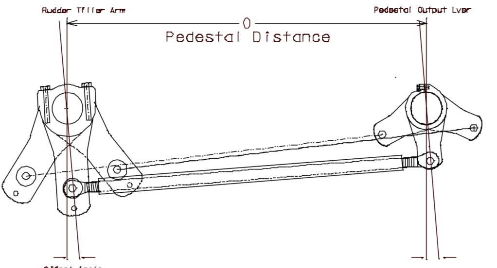
The steering wheel turns the pedestal output lever which then also turns the rudder tiller arm which is attached to the rudder. The pedestal output lever and the rudder tiller arm both move in unison because they are connected by a rod called the drag link. In our case, the drag link was too short and allowed the pedestal output lever to turn further than it should and rotate to the other side of the rudder tiller arm. This results in feeling like your steering is opposite of what it should be. That is exactly what we were experiencing. The fix was simple enough, we just needed to lengthen the drag link so this did not occur. We were able to rotate it to lengthen it by about 3/8″. We also noticed that when turning the rudder hard to port, the rudder was not fully hitting the port side rudder stop. So we also lengthened the arm for the autopilot to ensure that everything was aligned correctly.
All this adjusting then requires that we re-align the rudder and the steering wheel so that when the rudder is centered the wheel is also centered. I tried to walk over to another dock to see the stern of the boat so we could actually see the rudder but we were sitting too low in the water to effectively see the rudder. So, we had to take the dinghy down on the back of the boat to visualize the rudder and where it was when Mark was turning the wheel.
One more final adjustment, we had to recalibrate our autopilot so that the autopilot computer knew how to sense all these adjustments we made. And then we had to put everything back together and put all our tools and gear away.
All of that took 3 hours that we were not planning on after a long 10 hour journey. We ate some left overs and headed to bed.
We never even left the docks at Rogers City to see the town or explore anything, we were exhausted and we have another day of travel tomorrow.

Our next stop was Alpena, MI which is about 48 nautical miles from Rogers City. The harbors along the Michigan coast of Lake Huron are a bit more spaced out than what we experienced on Lake Michigan and the harbors are a bit more exposed, often with just a break wall separating the marina from the large lake. We left about 6:30 am.
Let’s talk about what passage making looks like aboard Painkiller. Typically we will be checking the mileage to our next proposed destination a day or two in advance to determine how far we want to go and we are typically checking the weather about 3 days out from any of our prosed passages and of course constantly as we progress. Weather forecast seem to be most reliable only 3 days out, typically anything beyond that is subject to changes. We often need to think about our proposed harbors at least a few days in advance and get online or call ahead for marina reservations if we plan to stay in a marina. Sometimes plans change due to limited marina availability.
The marinas along the western shore of Lake Huron are problematic for a couple of reasons, 1) they are spaced out at longer distances 2) they are often very shallow approaches compared to Lake Michigan and we have to carefully watch our depth meter and charts to ensure we don’t run aground 3) these marinas are not built up to handle the boat traffic of the cruising sailor or motor boater. Most cruisers do not frequent this area of Lake Huron. Why now? COVID and the closure of the Canadian border. The typical route would take most cruisers through the Trent-Severn Waterway which connects Lake Ontario with the upper portion of Lake Huron. For those who don’t follow the Trent-Severn Waterway, most cruisers would travel on the Canadian side of Lake Huron and not on the Michigan side because it’s more scenic, better harbors and deeper water. So, this year all the boaters and cruisers are traveling on the path less traveled on the western shore of Lake Huron with limited harbors.
Once we have determined where we are going, marina availability and checked the weather, it’s time to set the alarm clock. Yes, I know….we are retired and ditched the alarm clock awhile ago, however if you want to make some miles and get to a marina timely, say before all the staff leave for the day and before your stomach wants some dinner, ya gotta get up early in the morning.
Checklist for taking off:
- Get life jackets
- Turn on our Garmin GPS tracker
- Get the log book in the cockpit
- Camera
- Binoculars
- Journal
- Last minute check of wind and weather – dress accordingly
- Review how we will leave the dock
Typically Mark is behind the wheel and takes us off the dock and I am in charge of lines and fenders. Judging the wind and the approach to leaving the dock is important. How will the wind affect the boat when we remove a dock line? Yes, once last year, we miss judged this one and I almost couldn’t get aboard the boat! Mark will also set up our route and waypoints on our chart plotter before we leave so we have a clear path and understanding of where we are going.
Ok, now we are off the dock. Stow all the lines and put all the fenders away. Help look for bouys on the way out of the marina and get us on our way. Then it’s time to make coffee!
Now because we travel at about 5 miles per hour, which is a little faster than a brisk walk, we have a lot of time until our next arrival point. So, how do we fill the time? Watching for other boats of course, looking at our progress and route on the chart plotter, looking at the passing landscape, dodging the fleet of fisherman who sit a few miles off of any harbor/port or town. This is quite a different way to spend time. We have been known to have a 10 minute conversation about whether boat A is coming or going…hahaha… Sometimes we will do some journaling, work on a word puzzle book, read, listen to music, etc. We take turns with who is “watching” the helm while the other can relax and do other activities. The boat is on auto pilot 98% of the time and we just need to make sure we don’t bump into anything and adjust as necessary.
Today our distractions were about 3 boats that we met in Rogers City that we got chatting with last night. They said they were leaving in the morning to head to Detroit. Detroit! Why is that surprising? Well, Detroit is about 200 miles from Alpena. But hey they are power boats and go much faster than we do. But, we left at around 6:30 am and there was no sign that they were even up yet. We wondered what time they would come hauling up behind us on the way to Detroit. Keep in mind that they would need to basically go flat out full throttle for about 10 – 12 hours to make Detroit. They passed us about 10 am about 20 miles into our trip. I can’t imaging pounding in a power boat at full throttle for 10 – 12 hours.

The other distraction on this trip was watching and keeping up with the Chicago Mackinac Sailing Race that is happening right now on Lake Michigan. There is this great app that you can follow along and click on the boats to see all their details, where they are and who’s in the lead.

And of course the scenery.
And a ship wrecked sailboat!

Once we arrive in Alpena, we noticed several large tents set up in a large parking lot adjacent to the marina. Let’s check it out! Turns out they were having their annual Brown Trout Festival! This is complete with beer tent, food truck vendors, live music and a fun atmosphere. Nice! But no Brown Trout to be had, what’s up with that? We talked with some of the locals and asked, Where’s the Brown Trout? Turns out the population of Brown Trout in the area is greatly diminished from what historically had been here due to over fishing. However the festival lives on. They do still catch, tag and release 3 Brown Trout for the contest. If you catch the tagged Brown Trout, you win $50,000!

Next up Harbor Beach!
After our relaxed anchoring out in the Les Cheneaux islands, we headed back to St Ignace to drop off Camille so she could head back to Minneapolis. It was a windy day to head back and it was rather nerve racking to approach the marina and dock in 20 knot winds. But Mark did fabulous, as usual, and no dock or gelcoat was harmed in any way. We had some dinner across the street from the marina at a place called the Gangplank, really good food. The next day the shuttle van came to pick up Camille as we hugged and said our goodbyes.
After Camille left it was time for us to do a bit of route planning. We had planned quite a bit for our stops in Lake Michigan but hadn’t yet really considered where we were going to stop along the way in Lake Huron. Route planning involves looking at the charts for the area, looking at our guidebooks to tell us what sounds like an interesting town to visit, looking online for marina reservations or places to anchor. Michigan has made marina reservations a pretty simple process. Virtually all marinas in Michigan are owned and run by the Michigan DNR. They have a centralized website that you can go online to make reservations, see availability and even select the slip you want. Generally, unless is a very population spot like Mackinac Island, we are only reserving docks 2 – 3 days in advance. They are also pretty flexible in terms of weather changes too, since you can’t predict the weather. There have been several times we got somewhere and intended to stay only one night but added a second night at the last minute due to weather conditions and they have always been very accommodating.
We also look at several weather sources on a daily basis to determine which days are better for traveling and which days are better for staying at the dock. For wind forecasts, we look at Predict Wind and Windy, both apps for this purpose. We also look at weather radar for the local area we are in. We look at local weather forecasts from NOAA and we also look at the offshore weather forecasts for the Great Lake we happen to be on. They also have weather marine buoys in the middle of lake that gather weather data like wave heights, air temp, water temp, wind conditions, etc. You can actually text a specific buoy in the lake and it will text you back with the conditions at that buoy.
We also had to stock up on some groceries. The main grocery store in St Ignace is about a mile away. Before we left, we bought this great little cart made by Burley that can be used as a hand cart or attached to a bike. This is the first time we got it out and decided to bring it along for a grocery store run. We walked the mile or so to the grocery store, shopped, checked out and loaded up our little cart. We got some interesting looks from locals in the grocery store who were intrigued by our cart. But it was great! We were able to get a 12 pack of beer in the bottom and what would otherwise have been 3 bags of groceries all without a problem. And then we walked and wheeled our cart the mile or so back to the boat.

After we got back and put all our groceries away. We ran into this couple on the dock who owned this beautiful 44 foot Gozzard, which is a brand of sailboat. This is what a Gozzard looks like.
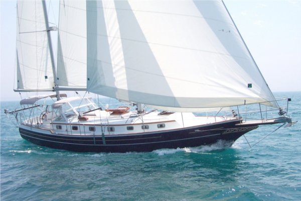
We walked by and complimented them on their beautiful boat, which turned into a rather lengthy conversation to learn that they are originally from Minnesota and the husband when to St Olaf College just as Mark did. Turns out they had the same major in college and some of the same professors. This conversation turned into happy hour which later turned into dinner at one of the places across the street from the marina.
This is exactly one of the reasons we love cruising is meeting new people and everyone we have met along the way have been so nice, friendly and helpful.
Given our rough timeframe to get through the Great Lakes this summer, we feel the need to put on some miles while the weather is good. It appears we will have great weather for the next 3 days, but it is looking like very little wind. One of the other considerations on Lake Huron is the upcoming annual Port Huron to Mackinac sailboat race. The race starts on July 24th in Port Huron, which is the very southern end of Lake Huron and they race non-stop for several days to reach Mackinac Island. Although the racers are going non-stop, there are always a fleet of other sailors and support people that travel along the race course and stop at the various marinas along the route. This means all the marinas along the route will be fairly booked during race time. We are hoping to get south of Port Huron prior to the start of the race so that we don’t have to compete for available marina slips.
There is also similar race called the Chicago – Mack race that runs on Lake Michigan from Chicago to Mackinac Island. That race just started yesterday and we have been watching the racers make their way north to Mackinac Island. We can watch the race on this cool racing app to see who is ahead. You can click on each little boat to see all the information about that boat.

Next up, cruising Lake Huron!
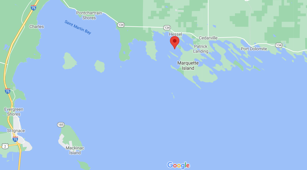
First, let’s start with how to pronounce these beautiful islands that are about 30 miles north of Mackinac Island. It’s pronounced Lay-Shen-O. They are a grouping of about 36 islands, some inhabited but most are very rustic wilderness and unspoiled natural beauty. It is in the northern most portion of Lake Huron in the upper peninsula of Michigan. This is as far north in our travels as we will go without the Canadian border being open to proceed further north in this area.
On the morning of July 12th we departed Mackinac Island and headed the 13 nm to Marquette Island and dropped our anchor in Wilderness Bay. Here are some of the photos from our approach into Wilderness Bay. There was this one compound/house? Not sure what it was but it was large and sprawling.


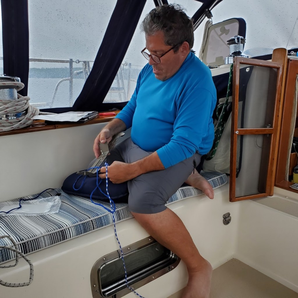
Anchoring here was straightforward. Lots of room. Good holding in mud and very peaceful Once we anchored, we were the only boat to be seen for miles. No one here. No internet. No cell service. Here’s Mark and I with the anchor down, getting the Mantus anchor bridle in place.

Our entertainment at anchor was the large eagles nest that had an adolescent eagle in it. Mom and offspring would be out flying and hunting. You could hear the young eagle crying for mom occasionally. It was like, “Hey, are you going to come back and feed me? It’s getting dark you know”. Spent a lot of time watching the nest and waiting to get some good photos. I think my patience paid off. Here is the nest with just the telephoto lens.

Here’s the same photo, zoomed in a bit:

I never got a photo of mom, but she was huge compared to the young one.
We also spent our time doing a bit of boat cleaning that Camille was extremely helpful with and pitched right in. We cleaned all the port hole windows, applied metal wax, applied silicon grease to the gaskets and cleaned all the screens. Had a nice relaxing dinner aboard and of course played some Mexican train.
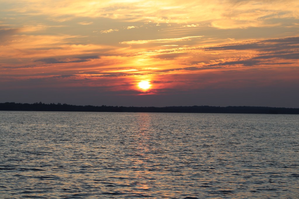
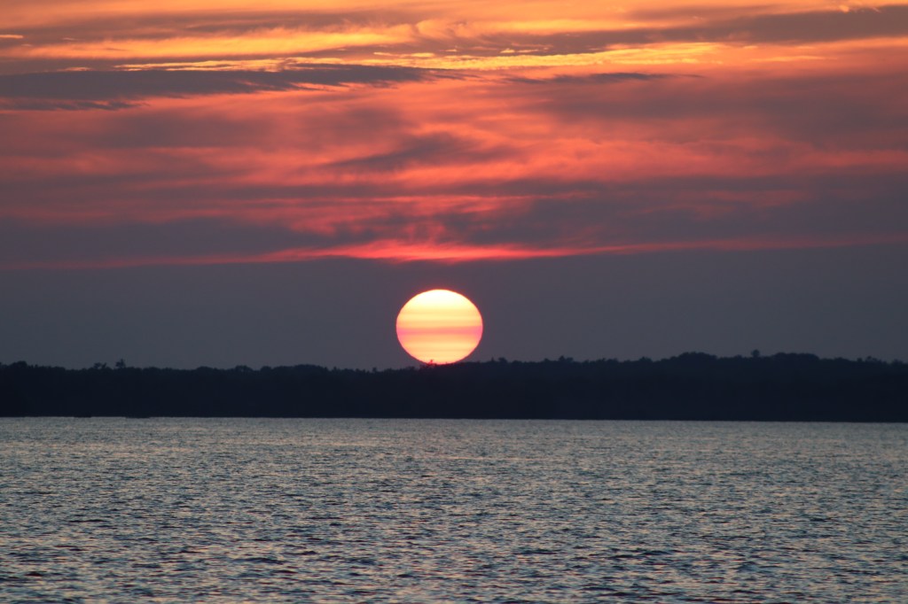
The sunset this evening was particularly spectacular. The sunset’s and sunrise’s have been particularly colorful due to wildfires in Canada.

The next day, we woke up to the peace and serenity that being alone at anchor affords. We knew we had some rain showers coming this morning and it rained for several hours starting mid-morning and into early afternoon. It wasn’t a storm front but a long passing shower. We spent the day inventorying the pantry to see what groceries we have used in the last month and what things we now need from the grocery store.
Mark also had time to make Camille a paracord bracelet as a bit of a birthday gift.
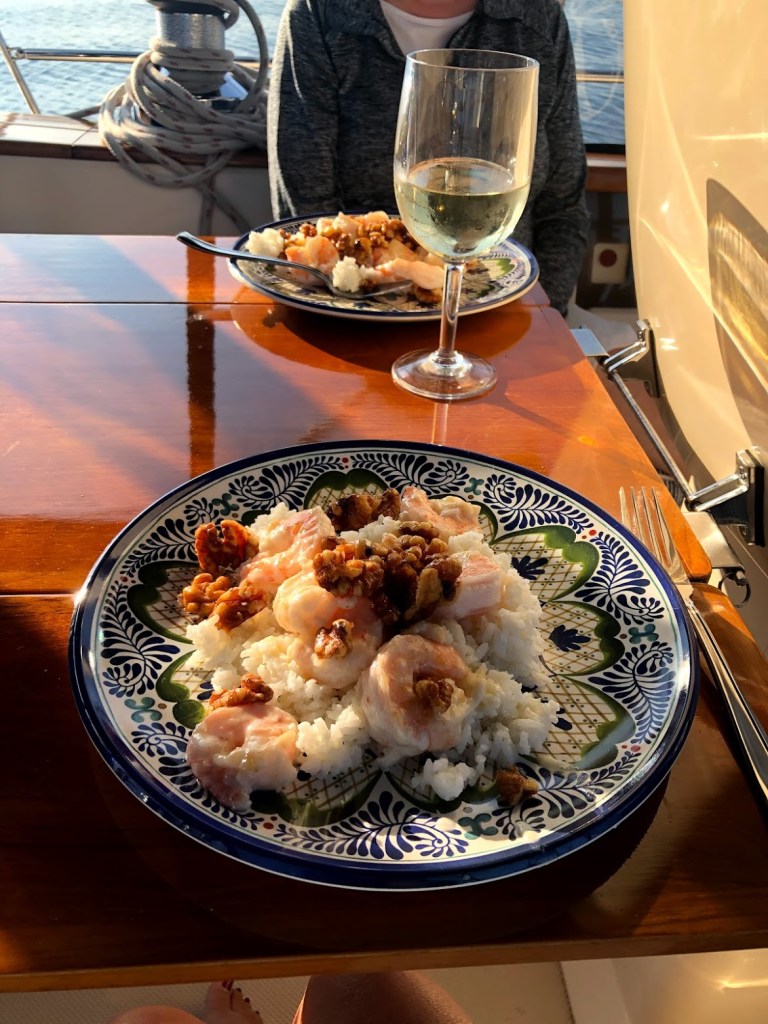
We made Walnut Shrimp for dinner. A dish that the 3 of us enjoy when we are together.
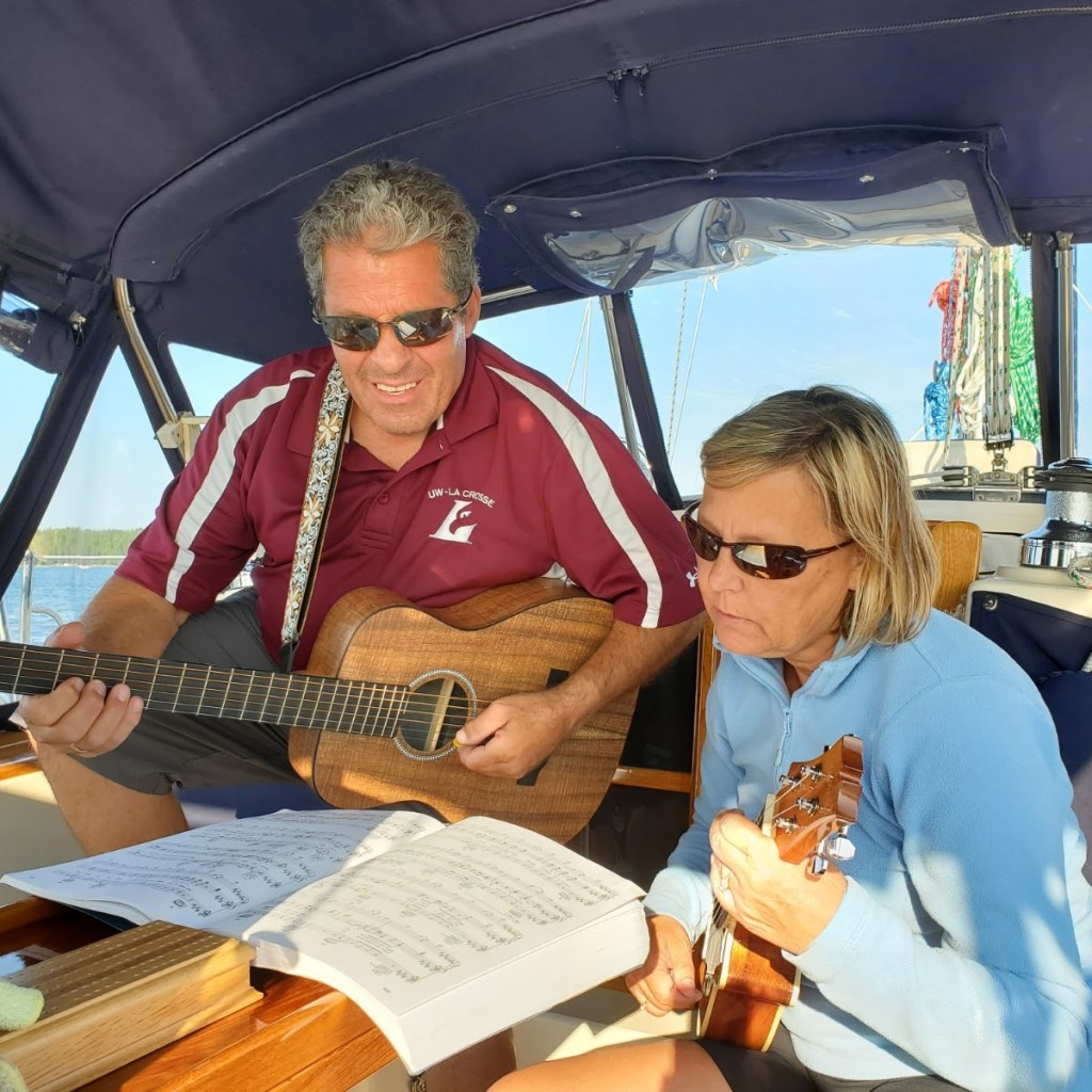
Then we had a bit of a sing along to the Eagles (no not the birds, the musical group). Mark and I broke out our guitar and uke to try to play along. Camille didn’t jump overboard at our attempt.
We played some more Mexican train and then just as we were about to head to bed. I peeked my head out in the cockpit one last time hoping to see the stars. As I entered the cockpit, I called below. “Woah! You guys have to see this!” We were enveloped in fog! You literally could not see past the confines of the cockpit and could not see the bow of the boat. We had the hatches open in the main area of the boat and we noticed that the fog started to fall through the hatch opening as if someone placed a fog machine right there. It was cool, creepy, awesome and weird all at the same time. Too bad you can’t really capture a photo of what this was like.
The next morning the fog had cleared to a beautiful sunny day with increasing winds. Today we would leave our secluded anchorage and head back to St Ignace as Camille will be departing us the next day to head home.

Yes, just in case you are confused Mackinac is spelled two different ways. The island is spelled Mackinac, while everything else, the city of Mackinaw, the straits of Mackinaw and the Mackinaw bridge is spelled Mackinaw. Don’t ask me why.
From St Ignace to Mackinac Island is just a short 1 hour sail. If going by ferry you could be there in about 15 minutes. They are very fast and there are a lot of them! They ferry people between St Ignace to Mackinac Island and from Mackinaw City to Mackinac Island.
Once we dodged all the ferries on the way over to the island and got settled into our slip, we spent the afternoon walking around town. We had a great lunch at the Great Turtle Brewstillery.


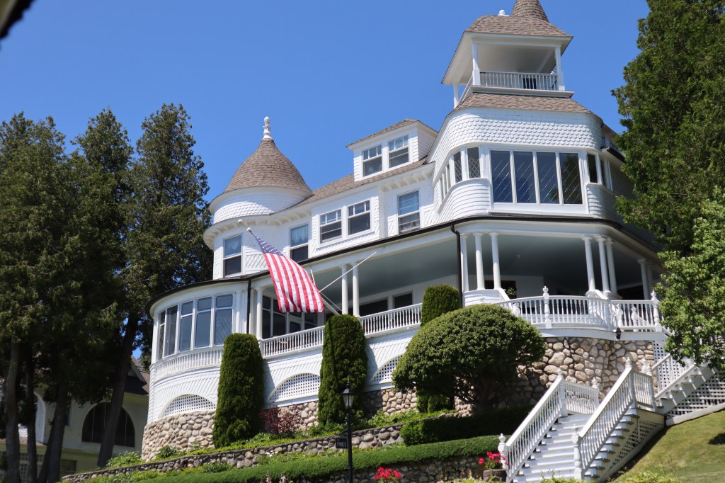
There are so many beautiful homes, buildings and historic shops in Mackinac that are picture worthy. One beautiful home in particular that is just ashore from the marina and currently sits right behind our boat is a bit of a sad tale. This 120 year old private summer cottage, had a house fire in May of this year due to a faulty chimney. They had to call fire crews from St Ignace and Mackinaw City to help extinguish the blaze. Unfortunately, the house has over $1 million dollars in damage. The good news is the private owners plan to completely restore the house.

Here are some additional cool historic buildings!


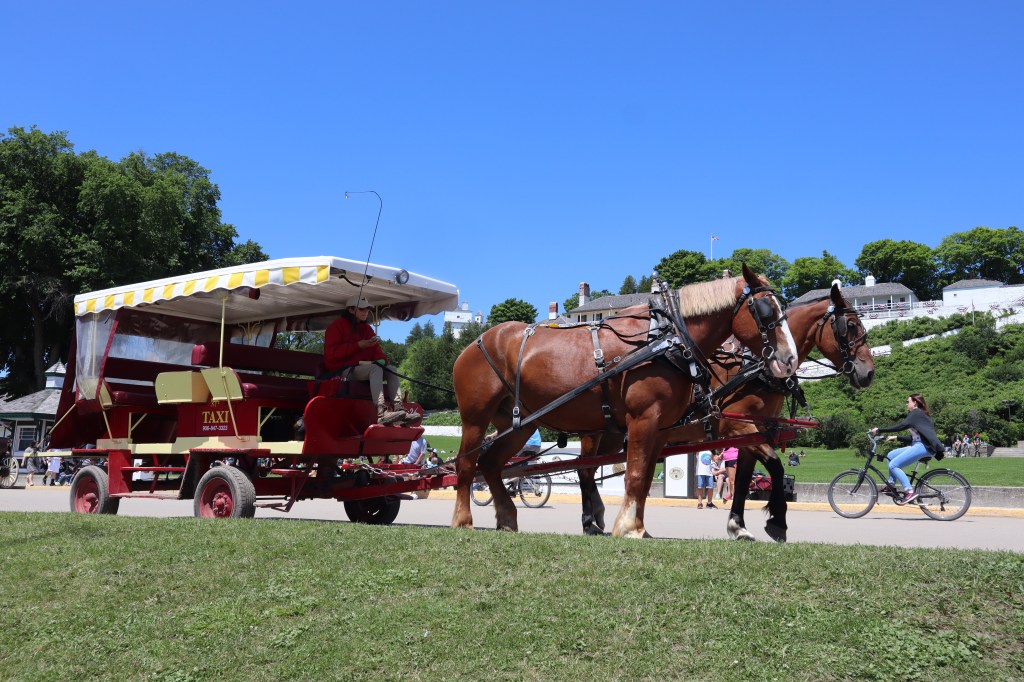
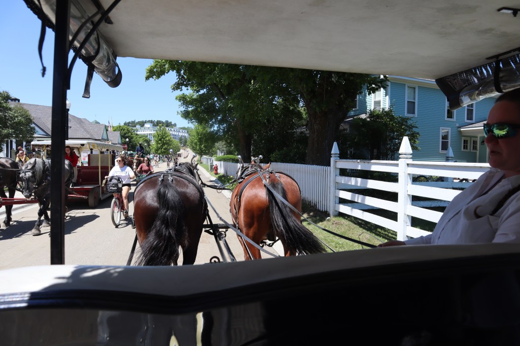
In case you are unfamiliar with Mackinac Island, the entire island is free of motorized vehicles. No cars, no golf carts (except on the golf course), not even electric bicycles are allowed. They only way options for getting around the island is 1) by foot, 2) by bicycle, 3) by horse. Yes, that’s right, lots of horse options. Horse taxi’s, carriages, horse back, wagon, etc. There are just a couple of motorized vehicles on the island. There is an ambulance, a fire truck and a police car. Here’s how to get around:
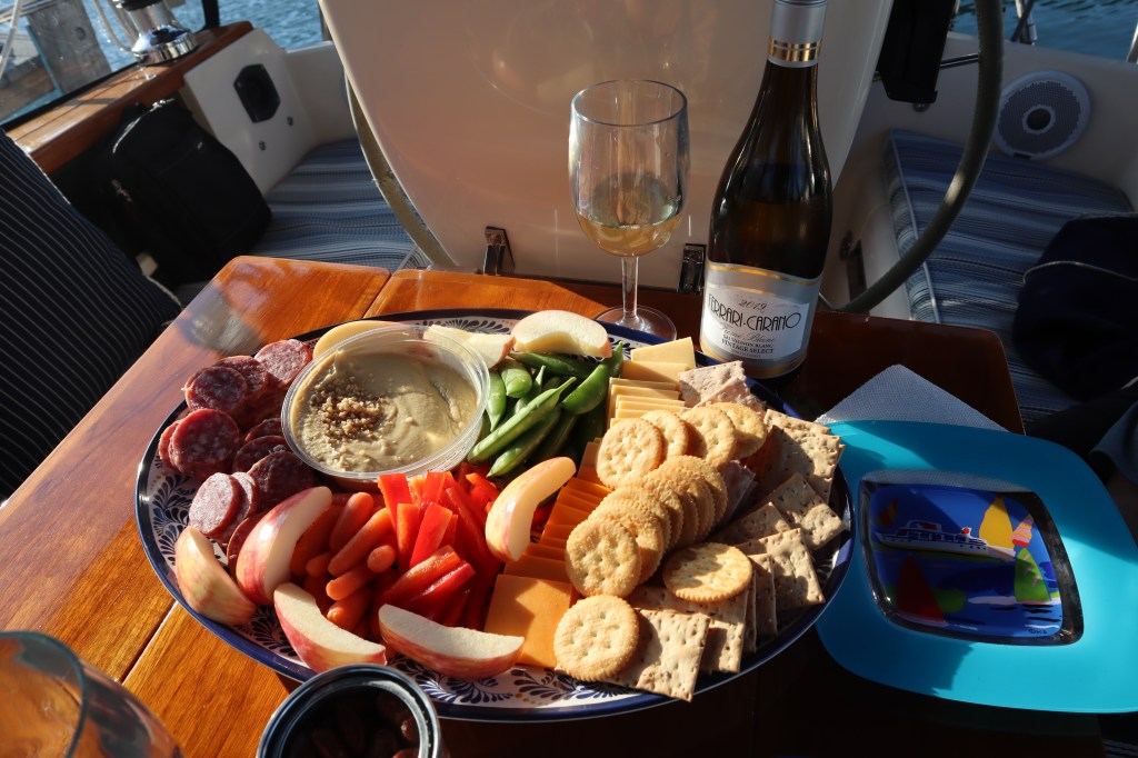
After exploring around town, we came back to the boat and had a light dinner and made a charcuterie platter and of course some happy hour drinks.
Mackinac Island marina had no wi-fi and there is very limited cell service in the area, so we entertained ourselves in between trips to town, eating and relaxing by playing cribbage.
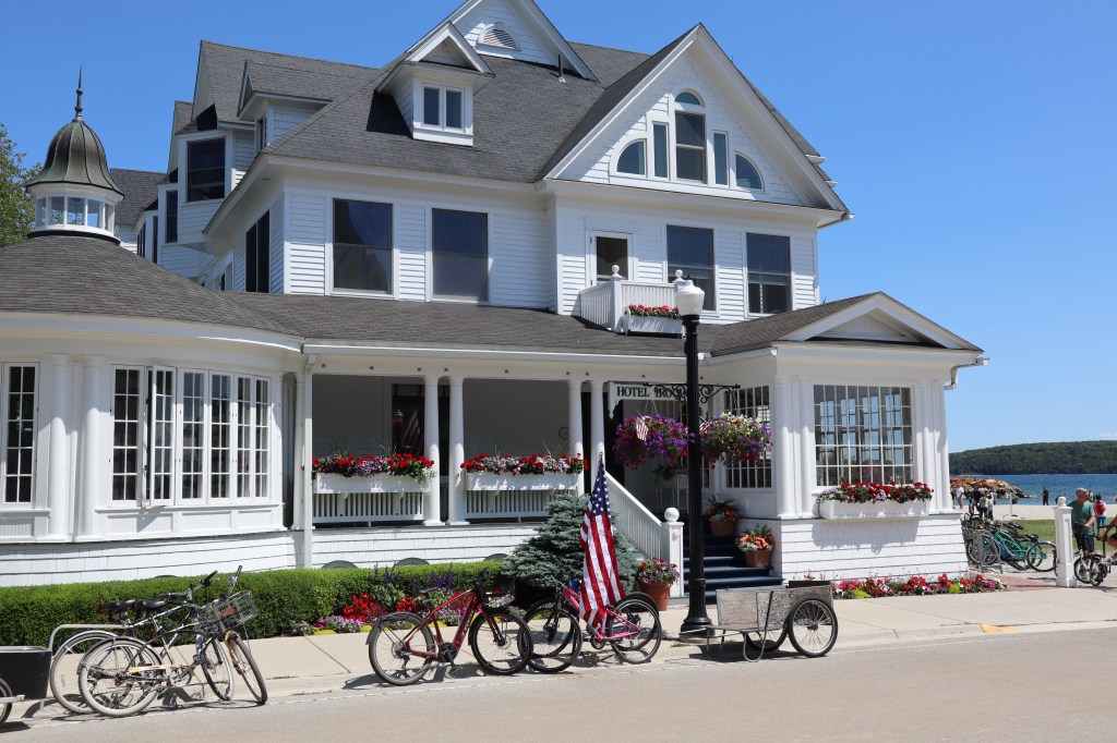
The next day our agenda included a walk and tour of the Grand Hotel. This hotel is 134 years old and was opened on the same day that we visited in 1887. The views from the front porch of the hotel are spectacular! The Grand Hotel porch by the way is the longest porch in the world and is 660 feet long.
Today is also Camille’s birthday! Happy Birthday Camille!!! We had a great time making the day special for her.

The inside of the hotel is just as spectacular as the outside.


But nothing beats how awesome the porch is:

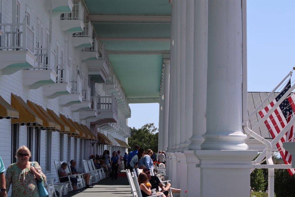

Well, except maybe the views from the porch!

We treated ourselves to a special lunch at the Carriage House after leaving the Grand Hotel. The Carriage House sits overlooking the harbor and is very upscale. It’s a birthday lunch for Camille.

We rounded out the day by hiring a private horse carriage ride to take us on a tour around the island. More spectacular homes and views! Our horses were Duke, that’s him on the left and Topper, on the right. They were great!


That’s our boat down there, photo taken from high on the hill during our carriage ride.

After all that activity, we had a quiet evening aboard the boat, some dinner and some home made brownies for Camille’s birthday!
The next day would be our last day on Mackinac Island before heading out again. Camille and I decided to do some shopping in town while Mark stayed back at the boat and filled our water tanks and did some general cleaning up. We really didn’t find anything that was worthwhile in the shops and came back to the boat empty handed.
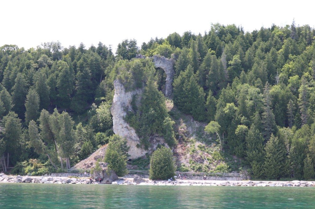
Today was a really calm day on the water and since the carriage tour didn’t get to taking us to see the arch rock, we decided to hop in the dinghy and take a dinghy ride around the island to see arch rock.


That evening we ate dinner at Winchester Whiskey & Bourbon Room. It was great food. Camille had the whitefish sandwich which was about as big as the plate and Mark and I split a burger. Camille and I got a great drink called a B&B smash. It was gin, basil, blackberries, lemon and honey. It was delicious.
Tomorrow morning we are departing Mackinac island. It was a beautiful 3 day stay!

We left off at Beaver Island, so on Tuesday July 6th we set an alarm (I know, I know….) and got up at 5 am so we could leave Beaver Island and head to St Ignace. This is about a 40 mile passage and will take us about 8 hours. We are heading to St Ignace to meet our friend Camille who will be joining us aboard Painkiller for about a week before we returns home again.
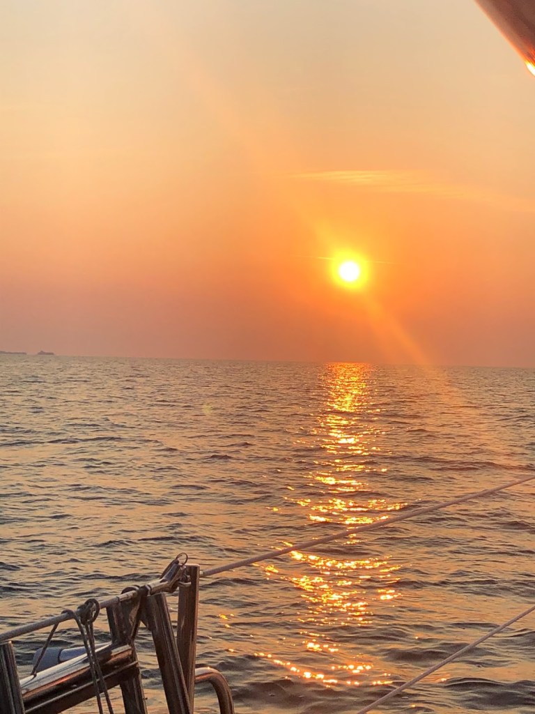
This is the beautiful sunrise that we were treated to as we left Beaver Island this morning. Some things are worth getting up for.
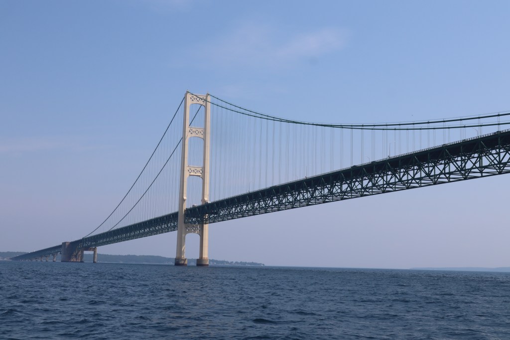
It was a beautiful wind day today with winds directly behind us at about 10 knots. It is days like today that we wish we had a spinnaker sail. The other highlight of this passage was crossing under the Mackinaw Bridge and entering Lake Huron, our second Great Lake.

We pulled into St Ignace around 1:30 pm and got settled and walked across the street from the marina to a great little restaurant called the Gangplank. It was great food and we were already exhausted and ready for a nap. We went to St Ignace a day earlier than we had originally planned because we knew there was a weather front coming in bringing rain and thunderstorms. The entire next day and the day after that ushered in the storm front and kept us aboard the boat. We literally didn’t leave the boat for about 48 hours. It was 55 degrees, raining, windy and not fit for human consumption outside.
We spent our days organizing, blog writing, reading, relaxing, made a pot of chili and some corn bread and did some laundry.
Thursday July 8th – Camille has arrived! She flew into Chippewa County International airport in Sault Ste Marie. She was able to find a shuttle to take her the 30 miles or so from the airport and drop her off at the marina in St Ignace. We are happy she has arrived! Let the fun begin! Camille has also brought with her some nicer weather! The clouds began to break up when she arrived!
After Camille arrived we headed out to eat at the Mackinac Grill right on the water just down the street from the marina. Then we headed back to Painkiller for cocktails and some Mexican train dominos.

Next up – Mackinac Island!
